Volumetric Oil in Place
Description
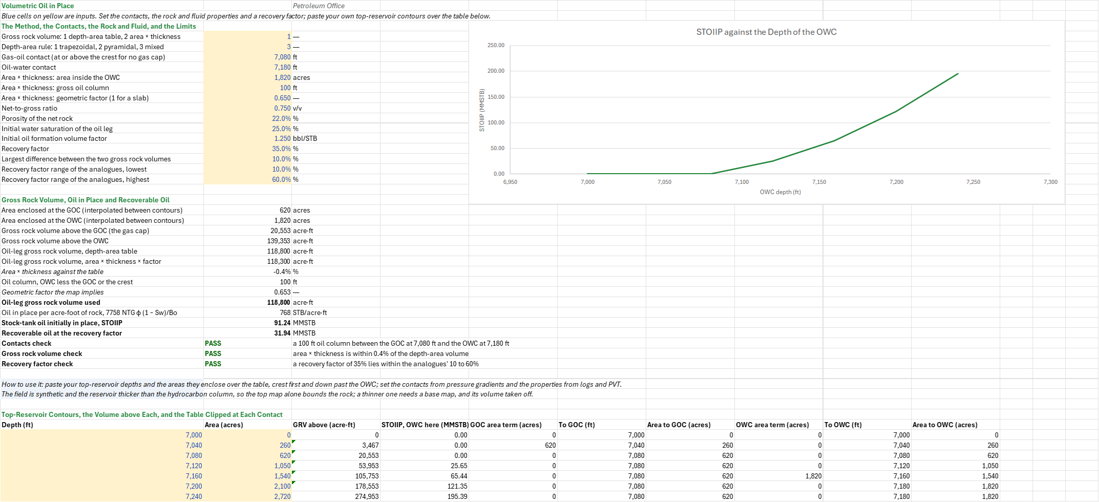
How much oil does the structure hold, and how much of it will come out? You enter the top-reservoir depth-area table and the gas-oil and oil-water contacts, or an area, a thickness and a geometric factor, then the net-to-gross, porosity, water saturation, Bo and a recovery factor. You read off the oil leg's gross rock volume by both methods and the geometric factor the map implies, the stock-tank oil initially in place (STOIIP) and the recoverable oil.
Parameters:
- Method:
VO_Method(1 the depth-area table, 2 area × thickness) and the depth-area ruleVO_DARule(1 trapezoidal, 2 pyramidal, 3 pyramidal where a slice's smaller area is at most half its larger) - Contacts:
VO_GOCandVO_OWC(ft TVDSS); a GOC at or above the crest means no gas cap - Area × thickness: the area inside the OWC
VO_Area(acres), the gross oil columnVO_H(ft) and the geometric factorVO_Factor - Rock and fluid:
VO_NTG,VO_Phi,VO_SwandVO_Bo(bbl/STB) - Recovery: the recovery factor
VO_RF - Limits:
VO_Tolfor the two volumes' difference, and the analogues' rangeVO_RFMintoVO_RFMax - Contours: each top-reservoir depth and the area it encloses, crest first, in the contour table
How to use it: The field is synthetic. Paste your top-reservoir contours over the table, crest first and on past the OWC: each depth and the area it encloses, planimetered or from the mapping package. Set the contacts from pressure gradients or logs, NTG, porosity and Sw from the petrophysics of the oil leg, and Bo from PVT at the initial pressure. Take the RF from an analogue (the Recovery Factor by Drive Mechanism sheet) or a forecast.
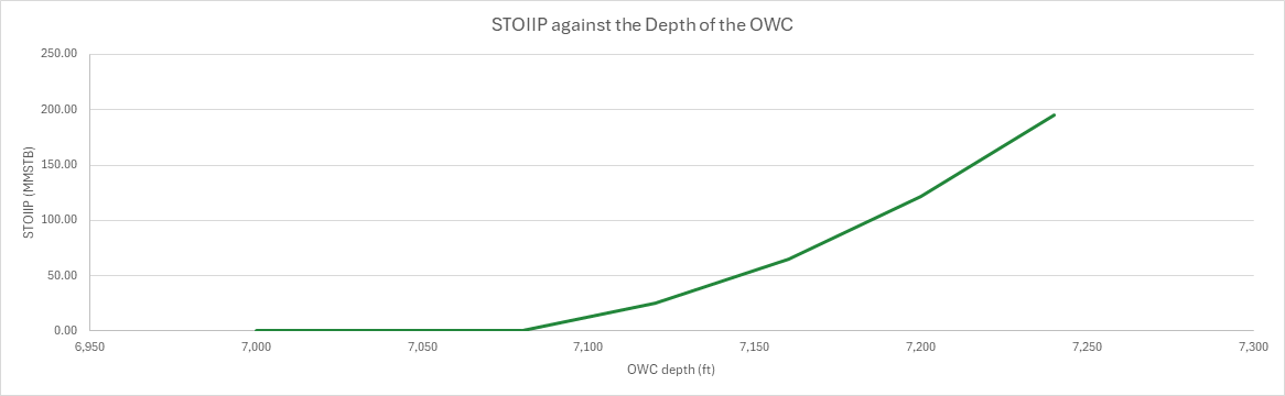
A contact rarely falls on a contour. Each contact's area is interpolated between the contours either side of it, and the table is clipped at the contact before it is integrated. The table also integrates the map down to every contour, and the chart draws the STOIIP an OWC at each depth would give.
Three checks give PASS, WARN or FAIL. The contacts check fails when the OWC is not below the GOC or lies below the deepest contour. The gross rock volume check warns when area × thickness differs from the table by more than the limit, and gives the geometric factor the map implies. The recovery factor check warns when the RF lies outside the analogues' range.
Method:
- Contacts. A contact's area is A_i + (C − d_i)/(d_{i+1} − d_i) (A_{i+1} − A_i), between the contours either side of it. Clipped at a contact, each contour keeps its depth and area above the contact and takes the contact's below, so the depth-area integration runs from the crest to the contact.
- Gross rock volume. The oil leg's GRV is the volume above the OWC less the volume above the GOC. By the other method it is A h F. The factor the map implies is the table's GRV over the area at the OWC times the oil column.
- In place and recoverable. STOIIP = 7758 GRV NTG φ (1 − Sw)/Bo, 7758 being the barrels in an acre-foot, and the recoverable oil is STOIIP × RF.
Example: The default case is the volumetrics family's synthetic field, which the gas-in-place and Monte Carlo sheets share. It is a four-way dip closure with its crest at 7,000 ft, a gas cap down to a GOC at 7,080 ft and an oil leg down to an OWC at 7,180 ft. The reservoir is thicker than the 180 ft hydrocarbon column. Its contours enclose 260 acres at 7,040 ft and 2,720 acres at 7,240 ft, the spill. The sand is 75% net with 22% porosity and 25% water in the oil leg; Bo is 1.25 bbl/STB and the recovery factor 35%.
The GOC at 7,080 ft falls on a contour and encloses 620 acres. The OWC at 7,180 ft falls between the 7,160 and 7,200 ft contours and encloses 1,820 acres. Above the GOC the map holds 20,553 acre·ft, the crest's slice by the pyramidal rule, and above the OWC 139,353, so the oil leg is 118,800 acre·ft. Area × thickness, 1,820 acres × 100 ft × 0.65, gives 118,300, 0.4% less and within the 10% limit; the map implies a factor of 0.653. Each acre-foot holds 7758 × 0.75 × 0.22 × 0.75 / 1.25 = 768 STB, so STOIIP is 91.24 MMSTB, and at 35%, inside the analogues' 10% to 60%, the recoverable oil is 31.94 MMSTB. The area × thickness method (method 2) gives 90.86 MMSTB, and the pyramidal rule throughout 118,074 acre·ft and 90.69 MMSTB. With no gas cap, the GOC at the crest, the 180 ft column holds 139,353 acre·ft and 107.03 MMSTB; area × thickness, still set for the 100 ft leg, falls 15.1% short, and the check warns. An OWC at 7,260 ft lies below the map and fails the contacts check, and a recovery factor of 5% warns.
Functions used
None: the blueprint calculates with Excel's own functions.
Names (41)
| Name | Refers to | Comment |
|---|---|---|
PO.RES.Vol.GRVLAMBDA |
=LAMBDA(Area, H, Factor, IF(OR(Factor<=0, Factor>1), NA(), Area*H*Factor)) |
Gross rock volume, acre-ft: area (acres) x gross thickness (ft) x a geometric factor (1 for a slab, below 1 for a dome or wedge). |
PO.RES.Vol.GRV.DepthAreaLAMBDA |
=LAMBDA(Depth, Area, Mode, LET(i, SEQUENCE(ROWS(Depth)), shift, --(i=TRANSPOSE(i)+1), d_prev, MMULT(shift, Depth), a_prev, MMULT(shift, Area), dh, ABS(Depth-d_prev)*(i>1), trap, dh*(Area+a_prev)/2, pyr, dh*(Area+a_prev+SQRT(Area*a_prev))/3, lo, (Area+a_prev-ABS(Area-a_prev))/2, hi, (Area+a_prev+ABS(Area-a_prev))/2, IF(Mode=1, SUM(trap), IF(Mode=2, SUM(pyr), IF(Mode=3, SUM(IF(lo<=0.5*hi, pyr, trap)), NA()))))) |
Gross rock volume, acre-ft, from a depth-area (or isopach) table: Mode 1 trapezoid, 2 pyramidal frustum, 3 pyramidal where the smaller area is at most half the larger, trapezoid otherwise. |
PO.RES.Vol.STOIIPLAMBDA |
=LAMBDA(GRV, NTG, Phi, Sw, Bo, 7758*GRV*NTG*Phi*(1-Sw)/Bo) |
Stock-tank oil initially in place, STB: 7758 x GRV (acre-ft) x NTG x porosity x (1 - Sw) / Bo (rb/STB). |
PO.RES.Vol.RecoverableLAMBDA |
=LAMBDA(InPlace, RF, IF(OR(RF<0, RF>1), NA(), InPlace*RF)) |
Recoverable volume: a volume in place (STOIIP or GIIP, any unit) x a recovery factor between 0 and 1; same unit as the volume in place. |
VO_Method |
$B$4 |
Gross rock volume: 1 depth-area table, 2 area × thickness |
VO_DARule |
$B$5 |
Depth-area rule: 1 trapezoidal, 2 pyramidal, 3 mixed |
VO_GOC |
$B$6 |
Gas-oil contact (at or above the crest for no gas cap), ft |
VO_OWC |
$B$7 |
Oil-water contact, ft |
VO_Area |
$B$8 |
Area × thickness: area inside the OWC, acres |
VO_H |
$B$9 |
Area × thickness: gross oil column, ft |
VO_Factor |
$B$10 |
Area × thickness: geometric factor (1 for a slab) |
VO_NTG |
$B$11 |
Net-to-gross ratio, v/v |
VO_Phi |
$B$12 |
Porosity of the net rock, % |
VO_Sw |
$B$13 |
Initial water saturation of the oil leg, % |
VO_Bo |
$B$14 |
Initial oil formation volume factor, bbl/STB |
VO_RF |
$B$15 |
Recovery factor, % |
VO_Tol |
$B$16 |
Largest difference between the two gross rock volumes, % |
VO_RFMin |
$B$17 |
Recovery factor range of the analogues, lowest, % |
VO_RFMax |
$B$18 |
Recovery factor range of the analogues, highest, % |
VO_Inputs |
$B$4:$B$18 |
The GRV method and depth-area rule, the gas-oil and oil-water contacts, the area-thickness inputs, net-to-gross, porosity, water saturation, Bo, the recovery factor and the check limits |
VO_AGOC |
$B$21 |
Area enclosed at the GOC (interpolated between contours), acres |
VO_AOWC |
$B$22 |
Area enclosed at the OWC (interpolated between contours), acres |
VO_GRVGoc |
$B$23 |
Gross rock volume above the GOC (the gas cap), acre·ft |
VO_GRVOwc |
$B$24 |
Gross rock volume above the OWC, acre·ft |
VO_GRVda |
$B$25 |
Oil-leg gross rock volume, depth-area table, acre·ft |
VO_GRVah |
$B$26 |
Oil-leg gross rock volume, area × thickness × factor, acre·ft |
VO_Diff |
$B$27 |
Area × thickness against the table, % |
VO_Column |
$B$28 |
Oil column, OWC less the GOC or the crest, ft |
VO_FactorMap |
$B$29 |
Geometric factor the map implies |
VO_GRV |
$B$30 |
Oil-leg gross rock volume used, acre·ft |
VO_PerAcreFt |
$B$31 |
Oil in place per acre-foot of rock, 7758 NTG φ (1 − Sw)/Bo, STB/acre·ft |
VO_STOIIP |
$B$32 |
Stock-tank oil initially in place, STOIIP, MMSTB |
VO_Rec |
$B$33 |
Recoverable oil at the recovery factor, MMSTB |
VO_ContactCheck |
$B$34 |
Contacts check verdict |
VO_ContactCheckNote |
$C$34 |
Contacts check comment |
VO_GrvCheck |
$B$35 |
Gross rock volume check verdict |
VO_GrvCheckNote |
$C$35 |
Gross rock volume check comment |
VO_RFCheck |
$B$36 |
Recovery factor check verdict |
VO_RFCheckNote |
$C$36 |
Recovery factor check comment |
VO_Results |
$B$21:$B$36 |
The areas at the contacts, the gross rock volumes above them, the oil leg's by both methods and their difference, the oil column and the factor the map implies, the volume used, STOIIP per acre-foot, STOIIP, the recoverable oil and three checks |
VO_Curve |
$A$43:$J$49 |
Each contour's depth and area, the gross rock volume above it, the STOIIP an OWC there would give, and the table interpolated and clipped at the GOC and the OWC |
Details
| Inserts | 49 rows × 10 columns |
| Category | Reservoir Engineering |
| For agents and tools | Descriptor (.md) |